
Chuck Schiereck
Author - Photographer
“There was nowhere to go but everywhere, so just keep on rolling under the stars.”
Jack Kerouac
Kayaking the ‘Lost World’ of Glacier Bay
1989
(Glacial Recession in Muir Inlet)
By Chuck Schiereck
August, 1989. Our guide was heading north, disappearing into the dense fog with six other boats strung out behind. Steep walls, confining the inlet, vanished into the grey soup overhead. I felt as if I’d been suddenly dumped into this strange environment accompanied by a sense of disbelief. Two days ago, I’d been in New Jersey packing out, the blur of airports and planes distorting any sense of distance.
Even with the lead boat out of sight in the fog up ahead, we knew where we were headed and I felt no obligation to stay bunched. This was a moment to savor, and I wanted to experience every bit. Twenty years ago, this stretch had been under ice, and the things we were seeing now were unimagined back then. Evidently, the kayaks behind didn’t feel the same way and they forged past, trying to catch up to the leaders.
I was in the front seat, setting a steady rhythm, while an old friend, Jack Sullivan, in the seat behind, was conforming to my pace. The cold humid air smelled of wet stone and little else. Scoured by glacial flows for centuries, these forbidding, barren shorelines were devoid of vegetation and wildlife. We kept on for a few more miles as the inlet, twisting to the right, obscured the view ahead. Our rudder was retracted and Jack was steering with his paddle; we’d been out before and were comfortable together. I knew the guides would be mixing us up tomorrow, and even though I felt the boats tracked better without it, that rudder would help us navigate with unfamiliar partners.

Muir Inlet, Glacier Bay, Alaska, 1989
We started to hear unexpected sounds, and a wall of ragged white ice emerged from the murk – Muir Glacier, dead ahead. From a distance, the glacier seemed to drop down gradually to the water. It was deceptive. The guide told us earlier that the ice face ranged in height from 60 to almost 200 ft., but it didn’t seem that tall from our vantage point.

Muir Glacier, 1989

Watching the Action, 1989
I could feel the surge as Jack leaned into his stoke, and the boat picked up speed as I pitched in. The glacier was further off than we’d thought and seemed to rise out of the water, getting taller with each stroke. The guide held up his paddle, shaking his head; we were close enough. I stopped paddling but left the boat in a glide, moving closer. Still almost two hundred yards away the fjord was filled with noise and we sat in our boats transfixed.
Alien sounds reached out: startling, foreboding. The glacier, like an army of dead frozen soldiers, jostled down upon us, unstoppable. Constantly shifting, with unimaginable weight forcing it down the valley, the ice was alive with creaking and groaning, producing a strikingly eerie scene of extraordinary power.
A sharp crack, like a gunshot, filled the air and echoed off the walls, rolling down the narrow bay behind us. The left face of the glacier separated, seemed to hang in the air, and then slid into the water. It took a moment before I could see the wave, and a bit longer before it reared up on us. The bow tucked under, then with a surge, lifted up sharply on the wave, driving home the point about not getting any closer. The sound was continuous – all in all, the creepiest natural occurrence I’ve ever experienced.
Reluctantly we turned our backs, knowing we’d never see this place again, few ever would; things were changing too quickly. Today it’s just a vivid, bittersweet memory of a place long gone. No longer reaching tidewater, Muir Glacier in 2016 has receded a good half mile back from its position in 1989. It grounded many years ago, and calving directly into the sea is a thing of the past.
There was a lot to talk about when we beached for lunch and this shared experience brought us together. We understood what we were seeing. This was not the behavior of a stable system; it was the last bits of a retreat that had been going on for centuries. Not just the result of ‘industrial-revolution climate change’, it was more complicated than that.
NASA Map courtesy Wikimedia
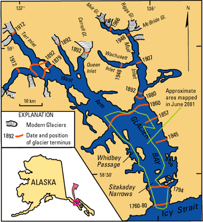
1794. Glacier Bay was first surveyed by a team from 'H.M.S. Discovery, captained by George Vancouver. At that time, the survey showed a mere indentation in the shoreline. (1)
We’d met the others two days before in Juneau, arriving from all parts of the US. Jack and I had started at Newark, NJ, changed planes in Seattle, and covered the distance to Juneau in a short hop. Often, it’s small things that make the biggest impression. There were mounted brown and polar bears at the airport, but it was the freshness of the air as I got off the plane that struck home – nothing smells like Alaska. The people are as wild and free as I’d been led to expect. On the cab ride to our hotel, the radio reported a fifteen-mile school of salmon and the driver wanted to dump us by the side of the road.
“Another cab will be right along for you.” He told us.
“It’s not happening.” Jack replied.
He didn’t seem angry, or out of sorts; I guess he thought it was worth a shot. We met the rest of our party at the guide’s office, then went out to dinner. A quick word about Alaska Salmon – it’s not like what you get back home. Never a seafood lover, it was a surprise to find myself ordering fish at every meal; not once ordering a steak even for old times sake.

Amphibious Otter

Pre-flight checks
Gathering at the airport check in counter, there were a few comments as it became clear that the guy who took the tickets and loaded the plane was also the guy who would fly it. The plane itself was a classic 1949 amphibious Otter, beautifully maintained, airworthy, seaworthy, and slower than dirt. The flight into Glacier Bay alone would prove to be well worth the cost of the trip. We headed into mountains, crossing between them through tight, wooded passes, then lumbered up the bay, finally dropping down onto the surface of Muir Inlet.
A bright sun had burned through the cloud cover when we returned to camp from the morning paddle. After securing the boats and stowing all the wet gear, we hiked up a dry barren gully to the west of camp. I don’t recall how long we climbed in the heat, to get us to a thin shelf of ice melting in the hot sun. As best I can figure, this was the last scrap of Burroughs Glacier, with its days numbered. I heard my name called and the guide was waving me over. He held out a chunk of ice, and I took it feeling like the victim of a practical joke. He pointed and told me to look closely. Inside, could clearly be seen an area of liquid water filled with small squirming worms. I’d never heard of anything like this. How’d they get in? What did they eat? What was their energy source? No one of us knew. Today you can get answers in a few clicks by doing a search on ‘Ice Worms’.

Death of a Glacier 1989

Dinner in the rain 1989
We’d all straggled back by early evening, just as the sky clouded over. I helped the guides prepare food, then drifted off to take some shots while there was still enough light. We ate dinner on whatever boulder seemed to be the best fit, but moved under the tarp as rain rolled in. Later in the half-light of the long Alaskan summer day, there was time to reflect on the beauty of this place. Straddling the overturned hull of a kayak, I found it hard to accept that things were changing so rapidly. There’s a good bit of speculation for the reason: rising temperatures, diminished summer cloud cover, and reduced snowfall in the accumulation fields seem to be the main culprits. Still, two centuries is a frighteningly short period for so much melting, whatever the cause. Some of us gathered, strangers now suddenly friends, chatting quietly, until heavy rain drove us to our tents.
1890. Muir Glacier was first visited by John Muir in 1880, but it was ten years later that Harry Fielding Reid, with Muir’s help, determined the extent of the glacier at Muir’s first visit. (2)

Muir Inlet at dusk 1989
A late start the next morning; all of the tents and camp gear had to come down, and get stowed in the kayaks' very limited space. Of the eight men in the group, five of them were named Steve and I drew one of them as my partner. After casting off, we headed ESE toward a large glacier that was just across the water, seemingly at arms length. At the time, Riggs was split into a north and south glacier. Deceptive, distance made the glacier seem smaller. In the north arm, we could see what appeared to be a large boulder. However, as we paddled closer it grew until it towered above us. It seemed that Riggs had recently grounded; now a terrestrial glacier, we could see a small shelf of mud and debris. I understood that this was the ebb period in the middle of August, and that winter would renew and extend the glacier out over the water.
Up until 1963, Riggs was just a tributary of Muir Glacier. Each year would bring a loss of thirty or so feet, and now, in 2016, Riggs no longer reaches the sea, while Muir Glacier has grounded, miles away to the north. Today vegetation is creeping back onto this rock as life pursues the retreating ice. (5)

Riggs Glacier 1989

The rock in Riggs Glacier 1989
Leaving Riggs behind, we all turned south. A stiff crosswind accompanied by a quartering sea, made paddling much more difficult; I was very glad to have the rudder. In some of the kayaking ‘armed camps’, a rudder is a sign of weakness, an admission that you lack the skill to control the boat with just your paddle. I view the rudder as a tool to be used when needed, in much the same way that I would use a hammer to drive a nail instead of using my forehead.
Waves hitting us off the port bow, threw up a constant spray of cold water. Steve, up in the front seat had it far worse then I, but he never complained. The boats were widely separated when we broke for lunch, after about ten miles on the open water.
Jack and I were wearing red Gore-Tex suits that we’d used in Nepal, and that didn’t sit well with the Alaskan guides. Still relatively new fangled, everyone else was using dark green rubberized rain gear. I stood out like a sore thumb, constantly hearing about it. We were all wet, because you always get wet when you work hard and sweat with a jacket on; there’s no avoiding it. Overall, I was pleased with the breathability of the suit and the zippered armpits that helped me ventilate. I’m sure it was more the color then the concept - all in fun.
1949. “Most of the worlds glaciers have been shrinking in recent decades, but in no locality have observations revealed more spectacular recession than the Muir arm of Glacier Bay in South-eastern Alaska” (2)
After lunch and a long nap in the sunshine, we headed south again. Vegetation and wildlife started to reappear, with stunted shrubs and grasses covering the areas behind the beaches; areas that had been out from under the ice longer. It was a unique experience, starting in a dead zone and witnessing the progression of life as we paddled south.

Haunting and Mysterious - Washusett Inlet 1989
There were other changes occurring that wouldn’t be understood for a long time. The land was (and still is) rising rapidly in a ‘Post Glacial rebound’. Relieved of the pressure of the massive ice sheets, the solid earth was lifting, in much the same way that a mattress rises when you get off it. (4)
We kept moving south, covering another ten miles before crossing the Wachusett Inlet, and landing on the stone beach with a loud crunch. Exhausted, we pitched our tents on the grassy rise just off the beach. Warmer air today had mosquitos and flies out in droves, DEET kept them from biting, but they were still annoying.
Gathered under the tarp, the group was eating and joking in the slow drizzle. I moved off to sit alone by the shore.
The water was quiet now, empty; there were no waves lapping, no breeze. I gazed up into the inlet in the fading light, drawn by the deathly still water, almost liquid silver. Part of me always needed to know what’s beyond every bend. I wanted to get into the boat and head out that way, darkness be damned. What was up there? I’d never know - we weren’t going that way. Sometimes it’s better not to run down every hole; leave a few un-explored, let the pictures remain haunting and mysterious.
I rejoined the others and took care of a chore that was long overdue – we renamed the five Steve’s. Each was assigned a nickname that stuck. Actually, we renamed only four. Steve ‘The Guide’ got to keep his name.
Next morning, I drew a different Steve (aka ‘Ice Pick’), who wanted the front. The group would be crossing the bay and heading northeast toward McBride Glacier, where we’d be spending the night. Crossing was a long haul into the wind, where every break resulted in a long drift backward. I could see that Steve was having difficulty with his paddle, and I suggested he ‘feather’ it. A feathered paddle has the blades offset from each other, and most paddles are adjustable to accommodate it. To use a feathered paddle requires a twist of the wrist, an easy transition that requires no skill. It allows the exposed blade to slice the air and be less of an issue in stiff winds.
After crossing over, the boat slid into the lee of high ridges, cutting off the wind. A mid day climb up onto one of the sunny ridges was a welcome relief – a chance to get out and stretch. We followed a stream up through alpine meadows filled with Alaska Cotton Grass, Forget-me-nots and other less familiar vegetation. It was a breathtaking experience, with stunning views of the empty bay, ‘Baldies’ gliding below us, and mountain goats perched on impossible ledges; and yet it was the isolation more than anything else, that got to me. Today, over four hundred thousand tourists visit Glacier Bay each year, in cruise ships, charters, or individual excursions. I don’t know the number of visitors in 1989 but we saw no one – ever, no ships or planes or fellow kayakers. (6)
Back in the boats, and continuing north, there was a field of icebergs to navigate, and after rounding a headland, we could see and hear McBride Glacier across a long mud spit. McBride sits at the end of its own small cove, entered after a stiff paddle through a narrow channel. We were forced to dodge icebergs and push through some icy mush - the castoffs from McBride. Our boats were pulled out on a sheltered beach above the tide line; while we camped on a small rocky hill that projected into the sound. Memories of that night at McBride haunt me still. It was hard to sleep with the noise from the Glacier; my wild dreams, a reminder that nature doesn’t have an ‘off switch’.

McBride Glacier 1989

McBride Glacier 1989
At breakfast, I asked Karen to pair with me. She was a strong paddler with a lot of Colorado River miles under her belt. She wanted the rear seat and I was more than happy to give it up. A perfect morning, I needed the unobstructed front seat view for photography. After breaking camp, a few of us kicked off very early and paddled up the cove to get close to McBride. The water was like glass, no wind, and with little effort the boats would glide endlessly. Backlit, the glaciers seemed to radiate light, sparkling, translucent, and impossible to capture on film. We all understood that it was a rare privilege to be here.
When all of the boats were ready, we pushed out into open water, through the icy mush, and turned north. The sun and the wind were at our backs and coats were off in the warm air. We stopped for a leisurely lunch, and then prepared our gear for the pickup flight. Boats were cleaned up and gear stowed.
We heard the planes, like flies buzzing, long before we could see them, and they landed smoothly on the still water. A new group of bright eyes disembarked and stood together in a knot, waiting to be told what to do. Did we really look that green when we landed last week?
One of the guides with the new group made a comment about my Gore-Tex suit. Without a word, I zipped the jacket and walked into the bay up to my chest. Icy water rushed in and my muscles started to knot as I staggered out. I thought I was going to die, but loudly proclaimed myself to be ‘warm and dry’, challenging the newcomers to do the same with their rubber suits. I got laughs but no takers – debate over. Back home, I’d need to do a few washings in powdered detergent to get the brackish residue out of the Gortex membrane, but it was worth it.
Looking back at the pictures and journal entries from that trip, it seems like yesterday; yet, so much has changed, glaciers vanishing, the land rapidly rising. I understand that I can’t go back. Blessed to have had my chance to visit this vanishing wilderness, old memories of a ‘Lost World’ will have to suffice.
Click for more Glacier Bay photography.


Sources
1 .John Muir, Travels In Alaska, Boston and New York, 1915, pp262-269
2 Glacier Recession in Muir Inlet, Glacier Bay, Alaska
William O. Field, Jr., Geographical Review
Vol. 37, No. 3 (Jul., 1947), pp. 369-399
3. Dr. Daniel E. Lawson. "An Overview of Selected Glaciers in Glacier Bay" (PDF). National Park Service. Retrieved 2010-08-15.
4 Post Little Ice Age Rebound in the Glacier Bay Region Roman J. Motyka1,2, Christopher F. Larsen1 , Jeffrey T. Freymueller1 , and Keith A. Echelmeyer1
//www.nps.gov/glba/learn/nature/upload/Motyka_etal2007_PostLittleIceAgeRebound.pdf
5. Riggs Glacier Retreat From The Sea, Alaska,
January 16, 2013 by Mspelto in Glacier Observations
6 Glacier Bay Flightseeing & Touring
http://fjordflying.com/flightseeing
Wikipedia: Glacier Bay Basin, Muir Inlet, Ice worms, Muir Glacier, Riggs Glacier, McBride Glacier, John Muir, Glacier Bay National Park